Geospatial data is being used more and more these days as telemetry and sensor technology improves. With almost every device able to emit a location signal, there is an increasing amount of geospatial data available. Elastic has introduced a new solution as part of Elastic Stack 6.7 that will provide more ways to visualize and analyze geospatial data. Elastic Maps will enable engineers to better manipulate and gain insights from that data, the company explained.
“Geospatial analytics is a search problem. Today’s location-based services and applications require real-time analysis of geospatial data,” said Shay Banon, founder and CEO of Elastic. “We’re super excited to release Elastic Maps, a new Kibana solution that expands upon our existing powerful geospatial querying, aggregation, and visualization features with pre-configured vector layers and base layer maps for developers, geo analysts, and business analysts to customize their maps any way they want.”
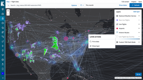
Elastic Maps supports the ability to layer data from multiple sources, such as overlaying weather patterns over flight data to determine the effect of weather on flights.
It also enables full control of styling data features and layer visibility on a map, enabling data scientists to provide additional map data, such as boundary layers, by indexing features from Elasticsearch as a Maps layer.
The solution also offers out-of-the-box preconfigured vector layers and base layer maps, which can then be altered with custom vector shapes, tile map services, or web map services as layers.